Middle East Physical Map Quiz
Share


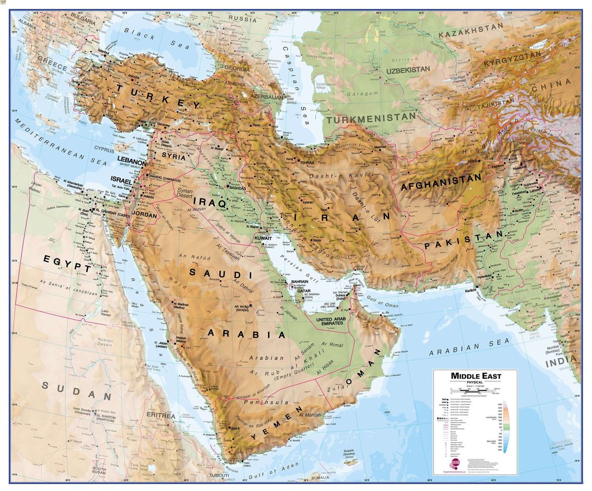
The Middle East is a region rich in diverse landscapes, from towering mountains to vast deserts and expansive seas. This quiz will test your knowledge of the physical features that define this unique area. Ready to challenge yourself and learn more about the Middle East’s geography? Let‘s get started!
We recommend that you do not leave the page that you are taking this quiz in. Stay honest 🙂
Middle East Physical Map Quiz Questions Overview
1. Which mountain range stretches across Iran?
Zagros Mountains
Himalayas
Atlas Mountains
Alps
2. What is the largest desert in the Middle East?
Sahara Desert
Gobi Desert
Arabian Desert
Kalahari Desert
3. Which river forms part of the border between Jordan and Israel?
Nile River
Jordan River
Euphrates River
Tigris River
4. What body of water lies between Saudi Arabia and Iran?
Red Sea
Mediterranean Sea
Persian Gulf
Black Sea
5. Which mountain is the highest peak in the Middle East?
Mount Everest
Mount Ararat
Mount Damavand
Mount Sinai
6. Which sea is bordered by Jordan, Israel, and Palestine?
Caspian Sea
Red Sea
Dead Sea
Black Sea
7. What is the primary river flowing through Iraq?
Nile River
Tigris River
Jordan River
Indus River
8. Which desert is located in southern Israel and extends into Egypt?
Negev Desert
Sahara Desert
Thar Desert
Atacama Desert
9. What is the name of the strait that connects the Persian Gulf to the Arabian Sea?
Strait of Hormuz
Strait of Gibraltar
Bosporus Strait
Bering Strait
10. Which river flows through both Turkey and Syria?
Nile River
Euphrates River
Ganges River
Danube River
We recommend that you do not leave the page that you are taking this quiz in. Stay honest 🙂
Can Your Friends Do Better Than You in This Quiz?
Share this quiz with your friends and compare results.


Was this page helpful?
More Popular Geography Quizzes:
-
 Top Quiz
Europe Quiz
-
 Top Quiz
Kenya Ferry Quiz
-
 Top Quiz
National Parks Quiz
-
 Top Quiz
Geography Quiz
-
 Top Quiz
Caribbean Island Quiz
-
 Top Quiz
Bing Mountains Quiz
More Interesting Quizzes For You:
-
 Top Quiz
Hololive Quiz
-
 Top Quiz
Pub Quiz
-
 Top Quiz
Narcissist Wife Quiz
-
 Top Quiz
Chlamydia Quiz
-
 Top Quiz
Triggers Quiz
-
 Top Quiz
Brain Candy Quiz